Trung tâm phòng tránh và giảm nhẹ thiên tai

Disaster Management Policyand Technology Center

Giao diện dễ tiếp cận vietnam english
Log in

Management - Cooperation - Work together

  • Homepage
  • About
    • About DMC
    • Organization Structure
    • Function & Tasks
    • Development stratery
  • News
    • National and International News
    • DMPTC News
  • Information Center
    • Disaster infomation
    • Basic knowledge
    • Library
      • Legal documents
      • Reference documents
      • IEC documents
      • CBDRM documents
        • Legal documents
        • Reference documents
        • IEC documents
    • CBDRM (Program 1002)
      • Project Matrix
      • Technical Assistance Network
      • CBDRM documents
        • Legal documents
        • Reference documents
        • IEC documents
      • Monitoring and Evaluation (M&E)
      • CBDRA
        • Disaster risks maps
        • CBDRA Reports
        • Other maps
      • Disaster prevention plans
    • Disaster risk maps
    • Irrigation systems
    • Trainings and Workshops
    • Gallery
  • Partners
  • Projects
  • DMC-Mail
  1. News
  2. Details
  • Share this on Facebook
  • Share this on Twitter
  • Share this on GooglePlus

Alaska Gov. Walker issues disaster declaration after major earthquake damages infrastructure near Anchorage

1:58:41, 01/12/2018 A large earthquake has rocked buildings in Anchorage and caused lamp posts and trees to sway, prompting people to run out of offices and seek shelter under office desks.
 The U.S. Geological Survey said the magnitude of the earthquake was 7.0, after initially giving a preliminary magnitude of 6.7.
No tsunami danger exists for the U.S. west coast, British Columbia and Alaska, according to the US National Tsunami Warning Center. The center had initially issued a tsunami warning for coastal zones of southern Alaska.
USGS says the earthquake Friday morning was centered about 7 miles (12 kilometers) north of Alaska's largest city, with a population of about 300,000. There were no immediate reports of any deaths or serious injuries.
All flights were halted at the airport after the quake knocked out telephones and forced the evacuation of the control tower, and the 800-mile Alaska oil pipeline was shut down while crews were sent to inspect it for damage.


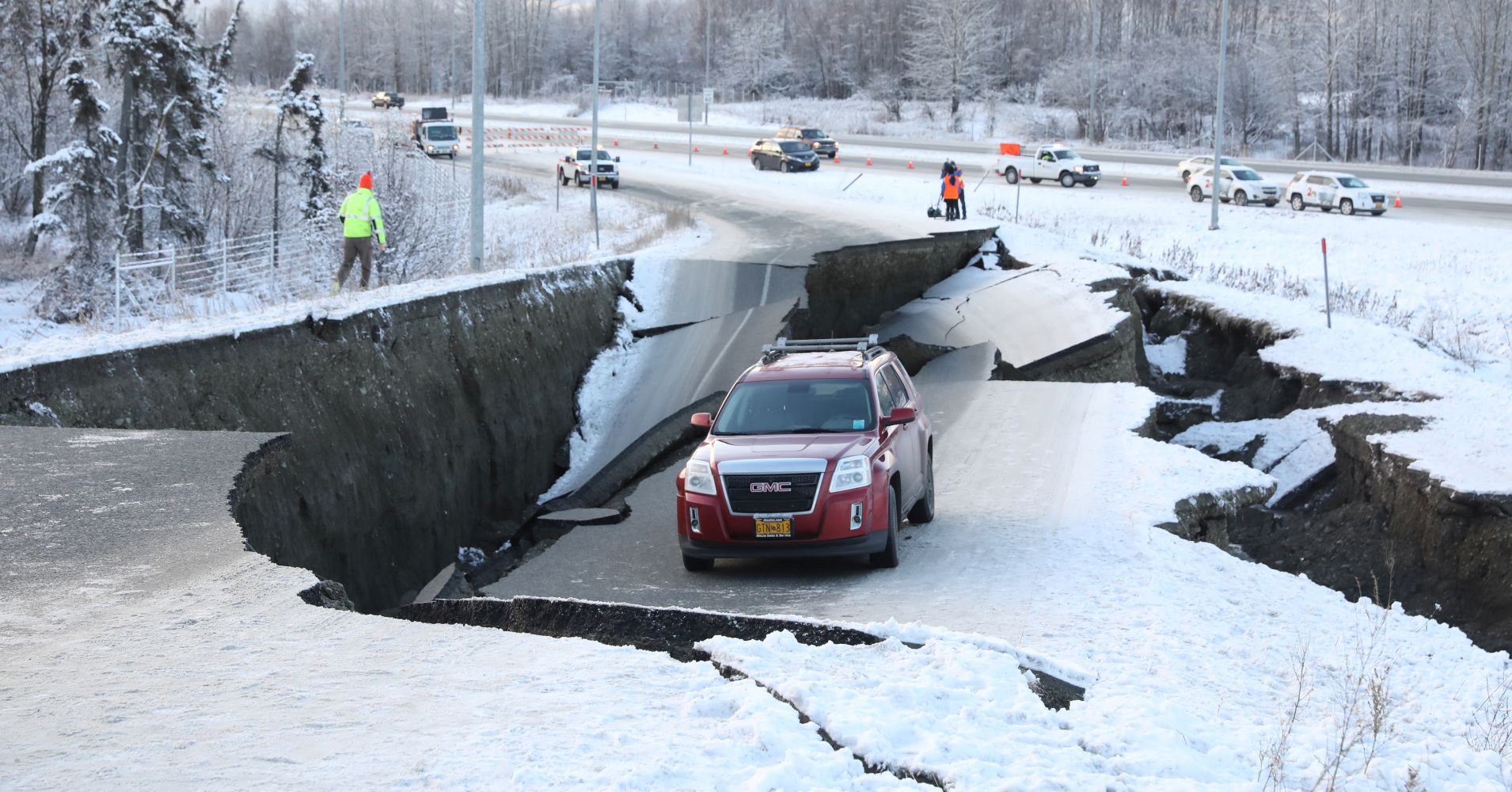
A vehicle lies stranded on a collapsed roadway near the airport after an earthquake in Anchorage, Alaska, U.S. November 30, 2018.

 Alaska averages 40,000 earthquakes per year, with more large quakes than the other 49 states combined.

Southern Alaska has a high risk of earthquakes due to tectonic plates sliding past each other under the region. According to the U.S. Geological Survey, the Pacific plate is sliding northwestward and plunges beneath the North American plate in southern Alaska, the Alaska Peninsula and the Aleutian Islands.
Alaska has been hit by a number of powerful quakes over 7.0 magnitude in recent decades, including a 7.9 that hit last January southeast of Kodiak Island. But it is rare for a quake this big to strike so close such a heavily populated area.


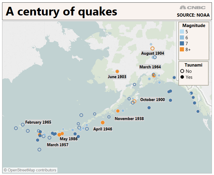
 On March 27, 1964, Alaska was hit by a magnitude 9.2 earthquake, the strongest recorded in U.S. history, centered about 75 miles (120 kilometers) east of Anchorage. The quake, which lasted about 4½ minutes, and the tsunami it triggered claimed about 130 lives.
(Source: cnbc.com)

Read more

  • Consolidation of Circular No. 13/2021/TT-BNNPTNT on Natural Disaster Prevention and Control Requirements
  • Advancing New Technologies in Natural Disaster Forecasting and Early Warning
  • Da Nang’s Civil Defense Mobilizes Combined Strength in Disaster Response
  • Death Toll in Ethiopia Landslides Rises to 125
  • Synchronizing Solutions for Flood and Landslide Control, Disaster Mitigation, and Early Warning Systems
  • Ho Chi Minh City: Criteria for ensuring natural disaster prevention and control in the use of construction works and housing
  • Northern Vietnam to see rain end from March 17 as sunny weather returns
  • Quang Tri: Addressing Coastal Embankment Erosion Near Vinh Moc Tunnels
  • Dyke Safety Prioritized from the Start of the Year
  • Science and Technology Must Be the "Lever" for the Water Sector’s Transformation


  • Vietnam Natural Disaster Monitoring System (VNDMS)

  • Community-Based Disaster Risk Management Database (Project 553)

  • Socio-economic database

  • Riverbank landslides, coastal erosion database

  • Spatial for disaster management database

  • Library Disaster Management Policy and and Technology Center

  • Damage database

  • Satellite database

  • Science and Technology Database

  • Online Knowledge Dissemination Software for Disaster Prevention

  • Digital transformation portal in disaster management

  • Camera Management and Monitoring Software

Weather forecast

Copyright © 2015 - Trung tâm Chính sách và Kỹ thuật phòng, chống thiên tai

Address: Số 54 ngõ 102 Trường Chinh - Kim Liên - Hà Nội

Phone: +84-436291511 - Fax: +84-437336647

Email: trungtamcsktpctt@gmail.com - Website: www.dmptc.gov.vn

Online users: 1311

Visistors: 94174