Trung tâm phòng tránh và giảm nhẹ thiên tai

Disaster Management Policyand Technology Center

Giao diện dễ tiếp cận vietnam english
Log in

Management - Cooperation - Work together

  • Homepage
  • About
    • About DMC
    • Organization Structure
    • Function & Tasks
    • Development stratery
  • News
    • National and International News
    • DMPTC News
  • Information Center
    • Disaster infomation
    • Basic knowledge
    • Library
      • Legal documents
      • Reference documents
      • IEC documents
      • CBDRM documents
        • Legal documents
        • Reference documents
        • IEC documents
    • CBDRM (Program 1002)
      • Project Matrix
      • Technical Assistance Network
      • CBDRM documents
        • Legal documents
        • Reference documents
        • IEC documents
      • Monitoring and Evaluation (M&E)
      • CBDRA
        • Disaster risks maps
        • CBDRA Reports
        • Other maps
      • Disaster prevention plans
    • Disaster risk maps
    • Irrigation systems
    • Trainings and Workshops
    • Gallery
  • Partners
  • Projects
  • DMC-Mail
  1. News
  2. Details
  • Share this on Facebook
  • Share this on Twitter
  • Share this on GooglePlus

Chongqing suffered heavy rain, starting an emergency response system

9:31:24, 13/08/2020 Heavy rains across 33 districts and towns of this city caused the water level in 4 small and medium rivers within this city such as Du Giang and Doan Than rivers to exceed the warning level.


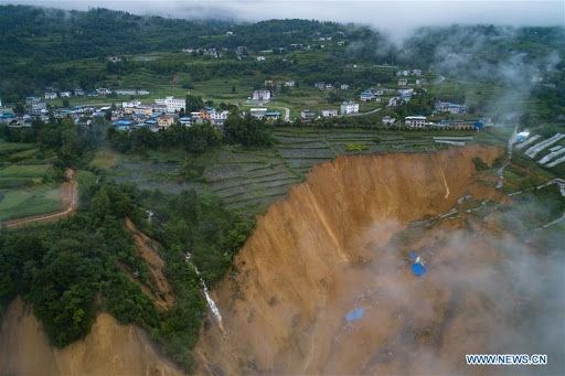
Heavy rain also caused landslides in an area of Chongqing. (Source: Xinhua News Agency)

The Vietnam News Agency correspondent quoted Xinhua as saying on July 26 that since July 25, Chongqing City has continued to suffer a heavy rain.

Heavy rains across 33 districts and towns of this city caused the water level in 4 small and medium rivers within this city such as Du Giang and Doan Than rivers to exceed the warning level.

During the period from 8 hours on 25/7 to 8 hours on 26/7, the largest rainfall measured in Long Son village, Kim Son town, Nam Xuyen district, Chongqing at 197.5mm.

In addition, heavy rain also caused landslides in the area of Luc Tinh village, Tho Dia village, Vu Long district, Trung Khanh.

This landslide disrupted the village's road traffic and blocked the flow of the Dien Thuong River, a tributary of the O Giang River.

The flow of the river blocked by rock has created a natural reservoir in the area, prompting local authorities to urgently evacuate people downstream.

In response to this heavy rain, the Chongqing Flood and Storm Control Committee soon issued a Level III flood warning at 13:00 on July 26, and had to start a response system emergency level IV flood prevention.

Districts, districts and related units are required to strengthen patrols, stay on duty, promptly mobilize rescue teams and emergency supplies and evacuate people in threatened areas./.

The Vietnam News Agency correspondent quoted Xinhua as saying on July 26 that since July 25, Chongqing City has continued to suffer a heavy rain.

Heavy rains across 33 districts and towns of this city caused the water level in 4 small and medium rivers within this city such as Du Giang and Doan Than rivers to exceed the warning level.

During the period from 8.00 on 25/7 to 8.00 on 26/7, the largest rainfall measured in Long Son village, Kim Son town, Nam Xuyen district, Chongqing at 197.5mm.

In addition, heavy rain also caused landslides in the area of Luc Tinh village, Tho Dia village, Vu Long district, Trung Khanh.

This landslide disrupted the village's road traffic and blocked the flow of the Dien Thuong River, a tributary of the O Giang River.

The flow of the river blocked by rock has created a natural reservoir in the area, prompting local authorities to urgently evacuate people downstream.

In response to this heavy rain, the Chongqing Flood and Storm Control Committee soon issued a Level III flood warning at 13:00 on July 26, and had to start a response system emergency level IV flood prevention.

Districts, districts and related units are required to strengthen patrols, stay on duty, promptly mobilize rescue teams and emergency supplies and evacuate people in threatened areas./.

(Source: Vietnam News Agency)

Read more

  • Consolidation of Circular No. 13/2021/TT-BNNPTNT on Natural Disaster Prevention and Control Requirements
  • Advancing New Technologies in Natural Disaster Forecasting and Early Warning
  • Da Nang’s Civil Defense Mobilizes Combined Strength in Disaster Response
  • Death Toll in Ethiopia Landslides Rises to 125
  • Synchronizing Solutions for Flood and Landslide Control, Disaster Mitigation, and Early Warning Systems
  • Ho Chi Minh City: Criteria for ensuring natural disaster prevention and control in the use of construction works and housing
  • Northern Vietnam to see rain end from March 17 as sunny weather returns
  • Quang Tri: Addressing Coastal Embankment Erosion Near Vinh Moc Tunnels
  • Dyke Safety Prioritized from the Start of the Year
  • Science and Technology Must Be the "Lever" for the Water Sector’s Transformation


  • Vietnam Natural Disaster Monitoring System (VNDMS)

  • Community-Based Disaster Risk Management Database (Project 553)

  • Socio-economic database

  • Riverbank landslides, coastal erosion database

  • Spatial for disaster management database

  • Library Disaster Management Policy and and Technology Center

  • Damage database

  • Satellite database

  • Science and Technology Database

  • Online Knowledge Dissemination Software for Disaster Prevention

  • Digital transformation portal in disaster management

  • Camera Management and Monitoring Software

Weather forecast

Copyright © 2015 - Trung tâm Chính sách và Kỹ thuật phòng, chống thiên tai

Address: Số 54 ngõ 102 Trường Chinh - Kim Liên - Hà Nội

Phone: +84-436291511 - Fax: +84-437336647

Email: trungtamcsktpctt@gmail.com - Website: www.dmptc.gov.vn

Online users: 1431

Visistors: 94174