Trung tâm phòng tránh và giảm nhẹ thiên tai

Disaster Management Policyand Technology Center

Giao diện dễ tiếp cận vietnam english
Log in

Management - Cooperation - Work together

  • Homepage
  • About
    • About DMC
    • Organization Structure
    • Function & Tasks
    • Development stratery
  • News
    • National and International News
    • DMPTC News
  • Information Center
    • Disaster infomation
    • Basic knowledge
    • Library
      • Legal documents
      • Reference documents
      • IEC documents
      • CBDRM documents
        • Legal documents
        • Reference documents
        • IEC documents
    • CBDRM (Program 1002)
      • Project Matrix
      • Technical Assistance Network
      • CBDRM documents
        • Legal documents
        • Reference documents
        • IEC documents
      • Monitoring and Evaluation (M&E)
      • CBDRA
        • Disaster risks maps
        • CBDRA Reports
        • Other maps
      • Disaster prevention plans
    • Disaster risk maps
    • Irrigation systems
    • Trainings and Workshops
    • Gallery
  • Partners
  • Projects
  • DMC-Mail
  1. News
  2. Details
  • Share this on Facebook
  • Share this on Twitter
  • Share this on GooglePlus

Flood water in rivers in Quang Binh province is rapidly falling

15:47:17, 09/11/2020

​By the afternoon of October 22, in Quang Binh province, there were still over 140 villages separated and isolated, of which there were 52 villages in the border area.


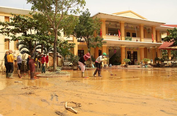
Teachers and parents of students at Vo Ninh Kindergarten, Quang Ninh District, Quang Binh Province cleaned the school and class again as soon as the flood water receded. (Photo: Van Ty / VNA)


On October 22, in Quang Binh province the sun reappeared, the weather warmed up, the water in the rivers was falling rapidly.

According to the report of the Steering Committee for Natural Disaster Prevention and Search and Rescue cum Civil Defense of Quang Binh Province, the water on the Gianh River at the Dong Tam measuring point below alert I was 0.98m; on Gianh river at the Mai Hoa measuring point under alert I was 1.45m; on Kien Giang river at the Kien Giang measuring point under alarm I is 0.42m; on Nhat Le river at Dong Hoi measuring point above alert I was 0.17m.

The reservoirs in Quang Binh province have the water flow down to the correct design capacity, the water in a few lakes exceeds the capacity but with a negligible rate such as Dong Ran exceeding 7.9%, Tien Lang lake exceeding 2 , 9, Trooc Trau lake exceeded 6.8%.

Due to the rapid water drop, on October 22, National Highway 1A had completely opened the route. In particular, the old National Highway 1A through the two districts of Quang Ninh and Le Thuy still has some light flooded points of about 0.3 m at Km681 (through Gia Ninh commune, Quang Ninh district) and Km68, Km697 (through Hong Thuy commune, Cam Lien commune, Le Thuy district).
The Ho Chi Minh Highway West branch, Highway 12 C, 12A, 9C, 9B ... still a few sections are divided, mainly due to landslides.

Currently, flooded areas in Le Thuy district, Quang Ninh, Minh Hoa, Ba Don town are rapidly decreasing; only about 35,000 houses remained inundated.

However, by the afternoon of October 22, in Quang Binh province, there were still over 140 villages separated and isolated, of which there were 52 villages in the border area.

Since the flood is considered "cataclysmic" appeared, up to now, there have been 8 deaths in Quang Binh, 44 injured.

Property damage is not currently listed./.
On October 22, in Quang Binh province, the sun reappeared, the weather warmed up, the water in the rivers was falling rapidly.


Read more

  • Yen Bai: Trees fell, houses had their roofs blown off, one person was injured due to a tornado
  • Dak Nong: Heavy rain accompanied by strong winds, greeting gates, trees in Gia Nghia city fell and fell
  • Malaysia records flood damage of over $210 million in 2024
  • Thanh Hoa: Escaped death when dozens of tons of rock fell on house
  • Ben Tre proactively responds to drought and salinity
  • The people of Lai Chau actively protect their livestock during the prolonged cold and severe cold weather.
  • Storm Tra Mi causes walls to collapse and roofs to be blown off in Quang Tri
  • Early resettlement for people living under landslides in Muong Nhe
  • Together, overcome difficulties, stabilize life
  • Nam Dinh evacuated nearly 500 households to safety due to the risk of rising flood waters.


  • Vietnam Natural Disaster Monitoring System (VNDMS)

  • Community-Based Disaster Risk Management Database (Project 553)

  • Socio-economic database

  • Riverbank landslides, coastal erosion database

  • Spatial for disaster management database

  • Library Disaster Management Policy and and Technology Center

  • Damage database

  • Satellite database

  • Science and Technology Database

  • Online Knowledge Dissemination Software for Disaster Prevention

  • Digital transformation portal in disaster management

  • Camera Management and Monitoring Software

Weather forecast

Copyright © 2015 - Disaster Management Policy and Technology Center

Address: No.54 - 102 Truong Chinh street, Dong Da, Ha Noi

Phone: +84-436291511 - Fax: +84-437336647

Email: trungtamcsktpctt@gmail.com - Website: www.dmptc.gov.vn

Online users: 301

Visistors: 19911474