Trung tâm phòng tránh và giảm nhẹ thiên tai

Disaster Management Policyand Technology Center

Giao diện dễ tiếp cận vietnam english
Log in

Management - Cooperation - Work together

  • Homepage
  • About
    • About DMC
    • Organization Structure
    • Function & Tasks
    • Development stratery
  • News
    • National and International News
    • DMPTC News
  • Information Center
    • Disaster infomation
    • Basic knowledge
    • Library
      • Legal documents
      • Reference documents
      • IEC documents
      • CBDRM documents
        • Legal documents
        • Reference documents
        • IEC documents
    • CBDRM (Program 1002)
      • Project Matrix
      • Technical Assistance Network
      • CBDRM documents
        • Legal documents
        • Reference documents
        • IEC documents
      • Monitoring and Evaluation (M&E)
      • CBDRA
        • Disaster risks maps
        • CBDRA Reports
        • Other maps
      • Disaster prevention plans
    • Disaster risk maps
    • Irrigation systems
    • Trainings and Workshops
    • Gallery
  • Partners
  • Projects
  • DMC-Mail
  1. News
  2. Details
  • Share this on Facebook
  • Share this on Twitter
  • Share this on GooglePlus

(Reuters) - The U.S. put its eastern seaboard on alert for Hurricane Irene on Tuesday as the powerful storm barreled up from the Caribbean on a path that could hit the U.S. coast on the weekend.

9:4:0, 24/08/2011 (Reuters) - The U.S. put its eastern seaboard on alert for Hurricane Irene on Tuesday as the powerful storm barreled up from the Caribbean on a path that could hit the U.S. coast on the weekend.

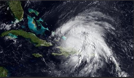
Even as the first hurricane of the 2011 Atlantic season pounded the Turks and Caicos Islands and the southeast Bahamas with battering winds and rain and dangerous storm surge, coastal residents in Florida and the Carolinas were preparing for Irene's approach.

Irene is the ninth named storm of the busy June-through-November season and looks set to be the first hurricane to hit the United States since Ike pounded the Texas coast in 2008.

It weakened on Tuesday to a Category 1 hurricane on the five-step Saffir Simpson scale of intensity, but could strengthen into a major Category 3 storm with winds over 111 miles per hour (178 km per hour) by Thursday, the Hurricane Center forecasters said

While warning the entire U.S. East Coast to be on the alert, Federal Emergency Management Agency Administrator Craig Fugate and National Hurricane Center Director Bill Read said it was too early to be certain where Irene would directly hit the coastline.

"We're going to have a very large tropical cyclone move up the Eastern Seaboard over the next five to seven days," Read said on a conference call in which he spoke along with Fugate.

The "best guess" forecast was that it would approach the coast of the Carolinas on Saturday morning as a major storm of Category 3 or upward, Read said.

After that, the already saturated New England region of the East Coast could also be at particular risk for torrential rains, high winds and flooding from Irene, Fugate said. Major eastern cities like Washington and New York could feel some impact from Irene, the forecast indicated.

In a separate development, a magnitude 5.9 earthquake struck the U.S. East Coast, shaking Washington, New York and other cities.

Irene could put a damper on Sunday's dedication ceremony for the new memorial honoring civil rights leader Martin Luther King Jnr. on Washington's National Mall. Tens of thousands of people, including President Barack Obama, were expected to attend.

Forecasts showed Irene posing no threat to U.S. oil and gas installations in the Gulf of Mexico.

Read more

  • Urgently overcome the consequences of flash floods in Bac Kan
  • Yen Bai: Trees fell, houses had their roofs blown off, one person was injured due to a tornado
  • Dak Nong: Heavy rain accompanied by strong winds, greeting gates, trees in Gia Nghia city fell and fell
  • Malaysia records flood damage of over $210 million in 2024
  • Thanh Hoa: Escaped death when dozens of tons of rock fell on house
  • Ben Tre proactively responds to drought and salinity
  • The people of Lai Chau actively protect their livestock during the prolonged cold and severe cold weather.
  • Storm Tra Mi causes walls to collapse and roofs to be blown off in Quang Tri
  • Early resettlement for people living under landslides in Muong Nhe
  • Together, overcome difficulties, stabilize life


  • Vietnam Natural Disaster Monitoring System (VNDMS)

  • Community-Based Disaster Risk Management Database (Project 553)

  • Socio-economic database

  • Riverbank landslides, coastal erosion database

  • Spatial for disaster management database

  • Library Disaster Management Policy and and Technology Center

  • Damage database

  • Satellite database

  • Science and Technology Database

  • Online Knowledge Dissemination Software for Disaster Prevention

  • Digital transformation portal in disaster management

  • Camera Management and Monitoring Software

Weather forecast

Copyright © 2015 - Disaster Management Policy and Technology Center

Address: No.54 - 102 Truong Chinh street, Dong Da, Ha Noi

Phone: +84-436291511 - Fax: +84-437336647

Email: trungtamcsktpctt@gmail.com - Website: www.dmptc.gov.vn

Online users: 5744

Visistors: 19911474